Polish software best for interpreting satellite images
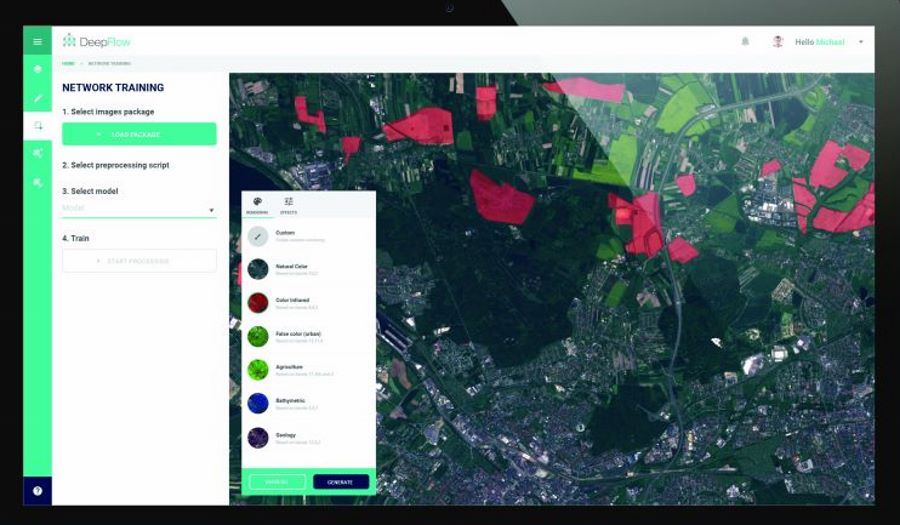
The innovative DeepFlow software from the Gliwice-based company KPLabs won the Copernicus Hackathon, a competition accompanying the Earth observation program run by the European Commission in cooperation with the European Space Agency. DeepFlow is the most efficient artificial intelligence software for interpreting data from satellite images.
DeepFlow, a project developed by Gliwice-based KPLabs, automates the search for relevant information „hidden” in róThe different layers of images sent by Earth observation satellites. The software will allow interpreting satellite imaging data for use e.g. in agriculture, industry or health care. KPLabs, within the FP Space consortium, coól will create a róAlso Intuition-1, a Polish satellite thatóry in 2022. will be in orbit around the Earth.
It is estimated that satellites belonging to the European Copernicus Earth observation program will provide as much as 10 petabyteóin (ok. 10 million GB) of data per year. According to the New York-based company P&S Research Market, in 2023 the global market for services based on satellite imaging will be worth approx. 5.2 billionóin the dollarów. Hence, there is a growing need to develop software, whichóre using artificial intelligence, will be able to automate processes related to the interpretation of image data, m.in. due to the cognitive limitations of human.
Software developed by KPLabs won the Copernicus Hackathon, whichórego participants are looking for new solutions for the use of data from satellitesóin the Copernicus program. The winning compositeóThe participants will have the opportunity to develop the application under the guidance of expertsóin the 10-month Copernicus Accelerator Program.
– We are currently developing DeepFlow very intensively, and as a start-up with global ambitions involved in building Intuition-1 within the FP Space consortium, we are trying to confront our idea with the market. Winning the Copernicus Hackathon will give us a deeper understanding of the use of satellite data and allow us to verify the market in a more global perspective – mówi Michal Zachara, Product Manager at KP Labs.
Thanks to DeepFlow’s integration with Copernicus and the Data and Information Access Services (DIAS) platform. The platform provides incoming data under the Copernicus program), it will be possible to process free satellite images sent from satellitesóin Sentinel and Landsat. With DeepFlow’s advanced deep learning technology, the computers are able to analyze very large data sets and help discover patterns in hundreds or thousands of images. However, the data requires preparation and further processingóbki, która is made possible by the use of deep networks and mechanismóin image correctionóin DeepFlow.
All this makes the time required to acquire information from the observed areaów is significantly krótszy. Using advanced machine learning technology, the best combinedół Copernicus Hackathon, using its application, will prepare data from satellite images and subject the images to the necessary processingóbce and correction according to the expectations of the recipients of theów.
Examples of the applications of software for reading satellite data and the benefits of the applications of this data are very wide:
- In agriculture, it can be used to classify land coveróIn, yield forecastingów, crop map, soil quality map, detection of chorób plants, biomass tracking, weed mappingów,
- In forestry can pomóc in classification lasóin, determining the speciesóin and health of the forestów, reforestation planning,
- In environmental protection by creating emission maps, pollution maps inód and soil, management and analysis of land useów.
KP Labs, as part of the FP Space consortium, którego members are also Future Processing and FP Instruments, is involved in the construction of the Intuition-1 satellite. The goal of the Intuition-1 mission is to conduct Earth observations using a satellite equipped with a hyperspectral instrument and advanced onboard data processing based on deep neural networks. It will be the world’s first satellite with processing power allowing image segmentationóin hyperspectral in orbit. It will carry a specialized camera with high spectral resolution in the visible light and near-infrared range. By dividing this band into 150 channelsów will be able to obtain significantly more information compared to the currently existing instruments on the marketów.
– The involvement of KP Labs in the FP Space consortium, is for me especiallyóA lnym moment in professional life. I have no doubt that we face challenges that few in the world do,” said Michal Baćkowski, Vice President of KP Labs. The Intuition-1 satellite will go into low earth orbit (LEO), and is scheduled for launch in 2022.

